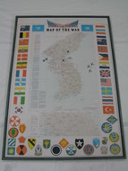
U.S. Stars & Stripes Magazine Korean Peninsula - Map of the War, 1953.
This is a map of the Korean Peninsula published by the Stars & Stripes magazine. The map details the major sites and features a border of the flags of the nations involved with the UN during the Korean War. It is an original propaganda piece that was published in tabloid format by the US Defense Department "Stars and Stripes" magazine in 1953 and it shows the key points of action in the area.
The Korean War took place from the 25th of June 1950 and finished on the 27th of July 1953 and it was a war between the Democratic People's Republic of Korea and the Republic of Korea. The political division of Korea following the end of WWII was the main cause of the fighting and this map pinpoints the primary battle sites as well as other important areas of action.
At the end of WWII, the rulers of the Korean Peninsula (the Empire of Japan) surrendered and this led to the American administrators dividing the Peninsula via the 38th Parallel. This meant that US forces occupied the southern area while the Soviet military occupied the north. The rift between the two sides deepened further as there was a failure to hold free elections, which meant that the south established a capitalist government and the north a communist one.
Before the war officially began in 1950, negotiations were attempted but failed leading to intensified tension. North Korea invaded South Korea on the 25th of June and open warfare began. The United States of America along with a handful of other countries worked hard to pass a security council in order to authorize a military intervention in the country. A total of 341,000 soldiers were sent in, with the USA providing a massive 88% of them. The soldiers helped the forces in South Korea to rebel against the invasion of North Korea and in total, 21 countries came to their aid alongside the USA. The Korean War was known as a proxy war as both South and North Korea were backed by external forces.
North Korea suffered from many casualties and after two months of fighting, they were left to defend a tiny area called the Pusan Perimeter in the southern area of the Korean Peninsula. North Korea was pushed back past the 38th Parallel almost as far as the Yalu River and it was at this time that the People's Republic of China intervened and took North Korea's side. This forced the allies of South Korea to retreat back to behind the 38th Parallel and the situation was made worse as the Soviet Union provided North Korea and China with material to help them to fight.
The armistice agreement was finally signed on the 27th of July, 1953 and this was when the active part of the war stopped. The border that sits between the Koreas close to the 38th Parallel was restored thanks to the agreement, and the Korean Demilitarized Zone was created that ran for 2.5 miles and acted as a buffer zone. However, minor infractions and fights still break out in the area today.
Sources:
Stewart Bell Jr. Archives Room, Handley Regional Library, Winchester-Frederick County Historical Society. From:
http://www.handleyregional.org/Handley/Archives/Korean%20War%201447.htm
Korean Demilitarized Zone, Wikipedia, 17 August 2012, from:
http://en.wikipedia.org/wiki/Korean_Demilitarized_Zone
Image Credits:
Zaricor Flag Collection


